In this webinar Eloise Nation will demonstrate the Explorer’s wealth of data and sophisticated functionality including:
• 880,000 bore locations and attributes
• Water levels for >230,000 bores in table and graph format
• Salinity measurements for >200,000 bores in table and graph format
• Hydrochemistry data from Geoscience Australia
• Bore log data and graphs
• Contextual map layers eg groundwater management areas, topography, geology & land use
• Advanced spatial and attribute search
• Data download packages
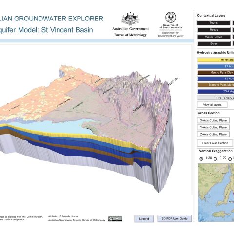
Eloise will also showcase the latest addition to the Explorer – enhanced 3D aquifer visualisations. These interactive 3D PDFs makes complex 3D data freely available online and offline, without the need for specialised software.
How does the Explorer work?
To explore the national dataset of groundwater information, you can pan and zoom using the interactive map, tailor search information for your area, view bore logs and aquifers in 3D, or download tables and graphs. Supporting information and extensive help functions allow you to find exactly what you need from this comprehensive tool. The Explorer is part of the Bureau’s groundwater information suite of national groundwater products. Take a look at the Bureau website to find out more.
Background
Groundwater data like water levels and bore logs are a fundamental input to any hydrogeological project from resource appraisals to modelling to environmental impact assessments. This data is now freely available from the Australian Groundwater Explorer for anywhere in the country. Through collaboration with state and territory water agencies, the Bureau of Meteorology collates and standardises jurisdictional groundwater data and publishes in the Explorer to support a wide range of users including all levels of government, private industry, research and the Australian community.
Attendee Registration Map