About

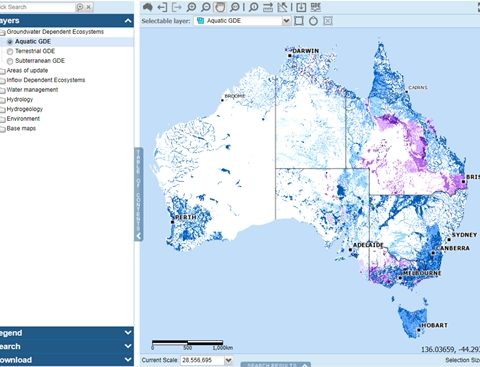
Understanding the role of groundwater in sustaining aquatic and terrestrial ecosystems is essential for natural resource management, environmental impact assessments and water planning. The GDE Atlas is a web-based mapping application housing standardised GDE data from across the country and allows the user to visualise, analyse and download data without the need for specialised software. In this webinar, Ben DiGregorio will run through the data and tools available in the Atlas and demonstrate how it can help you with your groundwater management and planning needs.

Presenters

Ben Di Gregorio

Bureau of Meteorology

Ben is a hydrogeologist with the Bureau of Meteorology, having joined the team this year. Ben is responsible for managing and updating the GDE Atlas and serves as the Secretariat of the GDE Reference ... Read more

Groundwater plays an important role in sustaining aquatic and terrestrial ecosystems, such as springs, wetlands, rivers and vegetation. Understanding these GDEs is essential for natural resource management, environmental impact assessments and water planning. The GDE Atlas was developed as a national dataset of Australian GDEs to inform groundwater planning and management. The atlas has also been updated to include data from subsequent detailed regional studies. It is the first and only national inventory of GDEs in Australia.

The GDE Atlas web-based mapping application allows you to visualise, analyse and download GDE information for an area of interest without needing specialised software. The application mapping tools have undergone a recent refresh to make the atlas more user friendly.

The Atlas contains information about three types of ecosystems:

  • Aquatic ecosystems that rely on the surface expression of groundwater–this includes surface water ecosystems which may have a groundwater component, such as rivers, wetlands and springs. Marine and estuarine ecosystems can also be groundwater dependent, but these are not mapped in the Atlas.
  • Terrestrial ecosystems that rely on the subsurface presence of groundwater–this includes all vegetation ecosystems.
  • Subterranean ecosystems–this includes cave and aquifer ecosystems.

The GDE Atlas was derived from a national-scale analysis based on a set of rules that describe potential for groundwater/ecosystem interaction and available GIS data. The atlas has recently been updated to include more detailed regional analysis undertaken by various State and regional agencies using a range of different approaches including field work, analysis of satellite imagery and application of rules/conceptual models.

Registrations Locations:


Screenshot of the GDE Atlas showing the location of Aquatic GDEs


Rimstone Pool, Kubla Khan Cave, Mole Ck Karst National Park, Tasmania


Karst Spring and tufa terraces, King Island