On-demand
QGIS essentials for groundwater: mapping and modelling
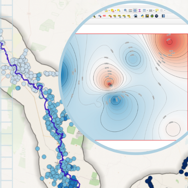
Compile groundwater data to process and create a groundwater map with QGIS
About
Take sessions at any time with unlimited access for 30 days on registration.
Focusing on an Australian river catchment as a case study, you will learn how load and import data into a QGIS project, process, interpolate and create layers from groundwater data and develop groundwater level maps from borehole data and DEM.
This course is designed for the beginner and is highly practical.
Don't miss this opportunity, register now for the course for self-pace learning!
Details
| Format | 3 x 2-hours recordings + course material and resources. |
|---|---|
| Cost | AUD $895.00 (INC GST) |
| Code | OD-24-3-105 |
| Contact | [email protected] |
| Tags | Groundwater / Modelling general knowledge / QGIS |
Register your interest: https://awschool.com.au/training/qgis-groundwater-modelling/
Presenters
Hans van der Kwast
QWAST
Hans van der Kwast has more than 20 years of experience with GIS and Remote Sensing in education and projects, offering consultancy, training and coaching in open source GIS. He is an active member in... Read more
Kurt Menke
Septima
A former archaeologist and ex-GISP, Kurt Menke is a geospatial generalist based out of Frederiksværk, Denmark. He received a Master’s degree in Geography from the University of New Mexico in 2000. ... Read more
Andreas de Jong
Educated at the University of Southampton and University College London (UK), Andreas de Jong is a freelance hydrogeologist and project manager with international experience in the water sector in ove... Read more