Take sessions at any time with unlimited access for 30 days on registration.
This course introduces participants to the rapidly evolving world of 3D geospatial data, with a clear focus on water management and hydrological analysis. Working with real‑world LiDAR, photogrammetry and drone‑derived point clouds, participants learn how to turn raw datasets into meaningful surfaces, models and visualisations that support evidence‑based decision making.
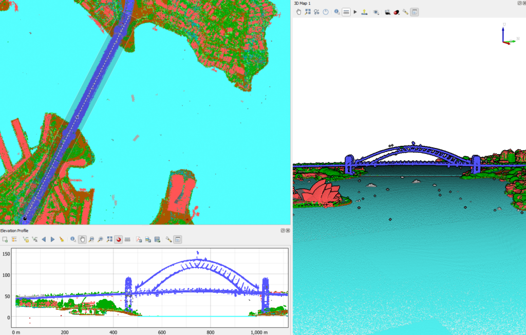
In this 3-part course, participants will generate point cloud data from drone imagery using WebODM and work hands‑on with QGIS’s native point cloud tools, 3D viewer and Elevation Profile functionality. The course builds confidence in exploring terrain, identifying hydrological features and preparing inputs for flood modelling and catchment assessment. Participants also learn to automate processing using PDAL wrench, QGIS’s integrated, multi‑threaded command line toolkit for fast, reproducible point cloud workflows.
By the end of the course, participants will be able to process, filter, visualise and edit point clouds with confidence, producing hydrologically relevant outputs such as DSMs, elevation profiles and feature derived layers that support modern water sector workflows.
On completion, you will be awarded an internationally recognised QGIS Certificate.
Hans van der Kwast has more than 20 years of experience with GIS and Remote Sensing in education and projects, offering consultancy, training and coaching in open source GIS. He is an active member in... Read more about Hans van der Kwast
Course Overview
This course introduces practical point cloud processing in QGIS, from visualisation and filtering to automated PDAL wrench workflows. Participants learn to create hydrologically relevant surfaces, explore terrain in 3D, and prepare high‑quality elevation products that support flood modelling, catchment assessment and modern water‑sector analysis.
Watch the intro video for a sneak peek into the course!
Learning Outcomes
In this course, you will be able to:
(Pre)process LiDAR, photogrammetry and drone point clouds to build reliable elevation inputs for hydrological modelling and terrain‑driven analysis.
Generate digital elevation models (DSM/DTM) using multiple interpolation methods, supporting flood modelling, flow‑path mapping and catchment characterisation.
Explore and interpret 3D terrain using QGIS’s 3D view and Elevation Profile tool, improving understanding of slopes, channels and hydrologically significant features.
Apply point‑cloud filters to extract features such as ground, vegetation or structures, enabling cleaner hydrological surfaces and more accurate runoff modelling.
Automate point‑cloud workflows with PDAL wrench to efficiently produce repeatable hydrological datasets for catchment studies, flood assessments and water‑sector decision‑making.
Course Outline
Part 1: From Imagery & LiDAR to Usable Point Clouds
Deriving point clouds from drone imagery using WebODM.
Loading and managing LiDAR tiles in QGIS.
Exploring point cloud datasets in 2D and 3D.
Creating Virtual Point Clouds (VPC).
Part 2: Filtering, Interpolation & Terrain Analysis
Applying point‑cloud filters (ground, noise, classification) and manual editing.
Generating DSMs and DTMs with interpolation methods.
Using the Elevation Profile tool for terrain and channel inspection.
Identifying hydrologically relevant features (slopes, flow paths, barriers).
Preparing elevation products for modelling workflows.
Part 3: Automating Workflows with PDAL Wrench & Editing Point Clouds
Introduction to PDAL pipelines and the PDAL wrench interface.
Build deeper capability in hydrological and environmental GIS with our suite of QGIS courses. From hydrological preprocessing and catchment analysis to field data collection and full‑workflow modelling, these courses give practitioners the tools, plugins, and spatial methods needed for real‑world applications.
In this eight‑part course, learn to delineate streams and (sub)catchments from digital elevation models with confidence and precision. Build capability across core QGIS tools, advanced plugins, and spatial reasoning to derive key hydrological properties including hypsometric curves, drainage density, and unit hydrographs. This course guides you to produce clear 2D and 3D visualisations, strengthening your practical skills in water modelling, spatial analysis, and hydrological interpretation.
In this three-part course learn how to build, run, and interpret groundwater models using QGIS tools. This course guides you through conceptualisation, model setup, boundary conditions, calibration, and visualisation, giving you a practical workflow for assessing aquifer behaviour and supporting groundwater‑related decisions.
This three-part course provides hands-on training on how to work confidently with mesh layers for hydrodynamic, coastal, and environmental modelling. This course covers loading, styling, analysing, and animating mesh datasets, giving you practical skills to interpret model outputs and create clear, decision‑ready visualisations.
In this three-part course learn how to streamline repetitive tasks and build custom geospatial workflows using PyQGIS. This course introduces scripting fundamentals, automation patterns, and practical examples that help you scale your GIS processes and boost productivity in QGIS.